
w131
Coit Tower
and
Telegraph Hill,
San Francisco
Coit Tower sits atop Telegraph Hill, the hill rising 275 feet above San Francisco Bay. Celebrants, finally getting word on October 29, 1850 that California had been admitted to the Union on September 9, ignited a signal fire on the hilltop, announcing the joyous occasion to the people of San Francisco. Over the years, the steep hillside leading up to the tower has provided homesites for Chileans, Italians, Irish, and in the 1890s, an artist colony. Today, expensive homes cover the hillside, vying for its coveted views of the city and bay. The tower rises an additional 210 feet, its shape designed to resemble a giant fire hose nozzle. The $100,000 used to construct the tower was bequeathed by Lillie Hitchcock Coit, who, as a child in 1851, was made an honorary member of one of the volunteer fire companies. She never forgot the honor. The hill and the tower are located in Pioneer Park and offer breathtaking views of the city and bay.
Directions: Take Lombard Street east past Grant Avenue. The road that winds up to Pioneer Park is on the right. There are directional signs on the roads.
Activities: Viewing the city and bay.
Dates: Open daily.
Fees: None.
For more information: City of San Francisco, phone (415) 666-7200. San Francisco Convention & Visitors Bureau, 201 Third Street, Suite 900, San Francisco, CA 94103. Phone (415) 391-2000.
Copyright 2015 by Publishing Syndicate, all rights reserved.
For permission to reprint text or photos contact Ken@PublishingSyndicate.com
w132
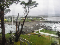
Crescent City
The city’s crescent-shaped bay and harbor are home to lumber docks for loading ocean freighters, several fish processing plants that handle the catch from local fishing trawlers, public boat slips, a launch ramp, and the U.S. Coast Guard headquarters. It’s a relatively small town, but it boasts a great beach at its southern end, directly adjacent to US 101. When the surf is decent, you can watch wetsuit-clad surfers riding the breaking waves.
As trade increased significantly along California’s rugged coast, especially with the Gold Rush, maritime safety became a significant issue along the rugged coastline. Dangerous winds and currents drove numerous wooden sailing ships into the rocky shoreline, often with significant loss of life in the cold, churning waters. In response to these growing tragedies, the United States began building lighthouses, first near some of the busier and more difficult-to-access and busiest harbors, and later along the more dangerous stretches of the coast.
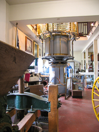
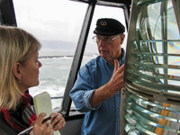
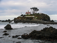
The Crescent City Lighthouse
was constructed in 1856 near the mouth of the bay. The lighthouse is accessible to the public, generally Wednesday through Sunday, from April through September, and when tides are low enough to get across the rocks from the mainland. The lighthouse contains a museum that is devoted to early maritime history and holds a collection of Tolowa Indian artifacts. Phone (707) 464-3089.
Pebble Beach Drive connects with Seventh Street in downtown, then parallels the coast as it heads north along the bluffs overlooking the Pacific. There are several pull-outs along the road and stairways to the beach area below.
Preston Island lies on the north end of Crescent City and really isn’t an island, but a spit. There’s a paved road off Pebble Beach Drive that leads to the island-spit, where great views and picnic tables await.
The masts of boats in the Crescent City Harbor are visible from adjacent US 101, at the south end of town. The public wharf portion of the harbor was originally constructed in 1950, and then rebuilt in 1987. During fogless evenings, the wharf is a great place to enjoy beautiful sunsets.
Directions: Crescent City is located on US 101, about 20 miles south of the Oregon border.
For more information: Crescent City/Del Norte Chamber of Commerce, 1001 Front Street, Crescent City, CA 95531. Phone (707) 464-3174.
Copyright 2015 by Publishing Syndicate, all rights reserved.
For permission to reprint text or photos contact Ken@PublishingSyndicate.com
w133
Eureka
It may be difficult to imagine how the rush for California’s Sierra foothill gold in 1850 could possibly have created the town of Eureka, so far north and on the coast. As the prospectors spread out from the central Mother Lode in the Sierra foothills, they found gold in many places throughout California. One of those early discoveries was along the Trinity River, near what today is the small, historic town of Shasta, in the northern part of the Sacramento Valley. These early miners also discovered that getting supplies was much easier if they were hauled by ship up the coast, landed at Humboldt Bay, then packed over the Trinity Alps, rather than being hauled by wagon or horseback up the often wet and swampy Sacramento Valley.
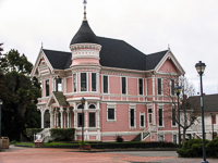
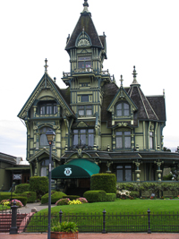
Eureka’s position near the entrance to Humboldt Bay assured its continuing success even as the gold petered out. It was timber, giant redwoods, and Douglas fir that drove Eureka’s continued growth and created millionaires of some of its citizens. One of those early lumber barons was William Carson. A grand and beautiful reminder of Carson’s wealth remains today. The Carson Mansion, a whimsical, three-story Victorian, was constructed in the 1880s and includes elaborate scrollwork, gingerbread, and other embellishments that help make it one of the most photographed Victorians in the country. It’s located near the waterfront, at Second and M streets in Old Town Eureka. Unfortunately, the mansion cannot be toured, only photographed from the street, from outside the fence.
Old Town Eureka covers several blocks near the waterfront, bounded by C and G streets and Third and Front. Many of the old buildings, including several Victorians that have graced the waterfront area since the latter half of the nineteenth century, have been restored and are now filled with a wonderful and eclectic collection of shops and restaurants.
One such gem is the Clark Memorial Museum, located in the historic, Roman Renaissance-style Bank of Eureka building at Third and E streets. Among its treasures from Eureka and Humboldt County’s histories is one of the largest collections of Northwest Indian basketry, some 1,200 pieces. Phone (707) 443-1947.
Humboldt Bay Maritime Museum is one of the many relatively small maritime museums found in the historic towns along the Pacific Northwest coast, from California to Washington. Eureka’s maritime museum, which is open daily, boasts ship models and other maritime artifacts both inside and outside the building. The museum is at 1410 Second Street, behind the Carson Mansion. Phone (707) 444-9440.
Blue Ox Historic Park, along with its small museum, is a wonderful place to watch modern-day craftsmen working with nineteenth and early twentieth century woodworking hand and power tools to create all the beautiful and intricate gingerbread that adorns Victorian homes. Private builders and restorers of famous historic homes from around the country place orders here for replacement
architectural millwork, from balustrades to turned porch columns. There’s a small fee to tour the complex, but it’s well worth a visit to the millworks and museum. For those so inclined, Blue Ox also offers classes in woodworking, blacksmithing, and pottery. The Blue Ox is located at 1 X Street in Eureka. Phone (800) 248-4259.
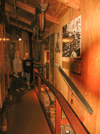
The Samoa Cookhouse is one of the more enjoyable places to eat in all of Eureka. This is the last surviving lumber mill cookhouse in all of California. Lumberjacks no longer eat here, but its long and fascinating history is captured in the old photos that cover all of the walls and the displayed artifacts, from the first chain saws to some of the cookhouse’s first stoves.
This is a great place to bring those teenagers or other big eaters who never seem to get enough food. The cookhouse serves three meals each day in a family-style setting, and the cook determines what is being served. Breakfast generally includes pancakes, scrambled eggs, bacon, sausage, juice, and coffee, and it’s all you can eat, as are all the meals. Dinner generally offers two main types of meat such as steak and ham. The prices are pre-set, and they are quite reasonable, considering that you get to enjoy your meal seated at long, picnic-style tables and can eat as much as the lumberjacks
Directions: The cookhouse is just off Route 255 in Eureka. From US 101 near the north end of Eureka, cross the prominent Samoa Bridge (there are directional signs to the bridge along US 101), which dead-ends into Route 255. Turn left onto Route 255, and the Samoa Cookhouse is easy to find by following the signs a couple of hundred yards down the road. Phone (707) 442-1659.
Directions: Eureka is located on US 101, about 278 miles north of San Francisco.
Activities: Shopping, sight-seeing, fishing, boating, bird-watching.
For more information: Eureka Humboldt County Convention & Visitors Bureau, 1034 Second Street, Eureka, CA 95501. Phone (800) 346-3482.
Copyright 2015 by Publishing Syndicate, all rights reserved.
For permission to reprint text or photos contact Ken@PublishingSyndicate.com
w134
Farallan National
Wildlife Refuge
The refuge is the largest seabird rookery along the eastern Pacific Ocean, south of Alaska. Each spring and summer, a quarter million seabirds visit the Farallan Islands’ steep cliffs and rocky outcroppings, lying just 27 miles west of the Golden Gate. Pigeon guillemots (Cepphus columba), rhinoceros auklets (Cerohinca monocerata), tufted puffins (Lunda cirrhata), common murres (Uria aalge), cormorants (Phalacrocorax sp.), and oystercatchers (Haematopus sp.) are some of the more common birds seen. Jaegers (Stercorarius sp.), shearwaters (Puffinus sp.), and albatross (Diomedea sp.) join birds that can be seen during boat trips around the islands. California sea lions (Zalophus californicus), northern elephant seals (Mirounga angustirostris), steller’s sea lions (Eumetopias jubatus), and harbor seals (Phoca vitulina) haul out on the narrow beaches and lower rocks or swim in the area, as do several species of marine turtles.
Many trips to the island include whale sightings, with blue whales and humpbacks being the most commonly observed during spring and summer. It’s also a thrill when pods of Dall’s (Phocoenoides dalli), Risso’s (Grampus griseus), or Pacific white-sided dolphins (Lagenorhynchus obliquidens) begin riding the boat’s bow wake.
The islands are off limits to visitors. The only way to view the islands’ wildlife is from a charter tour boat or a private boat.
For more information: Gulf of the Farallones National Marine Sanctuary, Fort Mason, Building 201, San Francisco, CA 94123. Phone (415) 561-6622. Oceanic Society Expeditions, Fort Mason Center, Bldg. E., San Francisco, CA 94123. Phone (415) 474-3385.
Copyright 2015 by Publishing Syndicate, all rights reserved.
For permission to reprint text or photos contact Ken@PublishingSyndicate.com
w135
Ferndale
Just off US 101 there’s a two-lane country road that crosses the Eel River, not far from its mouth, then meanders west through open farm and dairy land. The road finally enters a most intriguing historic Danish dairy town just before heading into the steep, coastal mountains of the Lost Coast to the west.
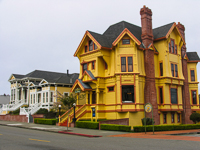
Ferndale’s concentration of grand Victorians, so many of them restored to their original colorful grandeur, were built by prosperous Danish dairy farmers who settled this rich bottomland in the nineteenth century. The farms remain prosperous, but today, it’s the thousands of tourists who visit the town each year who have helped spur the restoration of the elegant old homes, which originally were referred to as “butterfat palaces.”
The town’s main street is a kaleidoscope of colorful buildings that have been transformed into a wonderful collection of gift shops and antique dealers, restaurants and bakeries. The Ferndale Museum, located at 515 Shaw Street, has exhibits of early farm machinery, logging tools, furniture, and clothing.
One of the more intriguing museums to be found anywhere is the Kinetic Sculpture Museum, located at 580 Main Street. Inside, there are dozens of the human-powered contraptions that serve as the race vehicles in the Arcata to Ferndale Kinetic Sculpture Race. This annual three-day event, begun in 1969 by two Ferndale artists, requires individuals or teams to race their human-powered “sculptures” over land, sand, mud, and water. Some of the devices look like contorted combinations of bikes, boats, and giant caterpillars.
For those with several more hours to kill and a willingness to drive a narrow, mostly one-lane road, Main Street through Ferndale turns into Mattole Road and heads west into the forest and mountains. It ultimately emerges at the mouth of the Mattole River and Cape Mendocino, the northern end of an area called the Lost Coast, and the westernmost point in California.
Directions: About 14 miles south of Eureka, on US 101, turn south onto Mattole Road. It first crosses the historic Fern Bridge, then continues for about 5 miles to the town of Ferndale.
Activities: Shopping, walking, photography.
Facilities: Museums, bed and breakfast inns, restaurants.
Closest town: Eureka, 19 miles north.
For more information: Ferndale Chamber of Commerce, PO Box 325, Ferndale, CA 95536. Phone (707) 786-4477.
Copyright 2015 by Publishing Syndicate, all rights reserved.
For permission to reprint text or photos contact Ken@PublishingSyndicate.com
w136
Fort Bragg
Elegant Victorian homes and early twentieth century Craftsmen style buildings can easily recreate images of the old days. But in the old days, Fort Bragg went through many changes, not the least of which was complete destruction when the earthquake that destroyed most of San Francisco in 1906 did essentially the same in Fort Bragg.
The Pomo Indians had inhabited this land of ocean and redwoods for thousands of years by the time the United States acquired California in 1846. Four years later American maritime traders discovered this area’s potentially profitable redwood forests when The Frolic crashed on the coastal rocks and scavengers came to salvage what they could. The Bureau of Indian Affairs soon arrived, and their goal was to place the Pomo Indians on a 25,000-acre reservation. In spite of the bureau’s efforts, the Indians remained hostile to the American intruders. The army was brought in the following year to establish a fort that was designed to help subdue the Indians and ensure peace in the area.
After the fort was abandoned in 1864, the growing community depended upon logging redwoods to provide for their support. The many small lumber companies that formed during those early years were soon dwarfed when C.R. Johnson founded the Redwood Lumber Company in 1885. Fighting back, in 1891, many of the smaller mills joined forces, forming the Union Lumber Company.
Johnson was elected the first mayor of Fort Bragg when the city was incorporated in 1889. Its name honored Colonel Braxton Bragg, the man whose name was also later given to Fort Bragg, North Carolina. San Francisco’s 1906 earthquake destroyed most of the town’s buildings, but the mills were soon producing the thousands of board feet of lumber needed to rebuild itself and San Francisco.
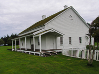
Guest House Museum is located on Main Street (Highway 1), between Redwood and Laurel streets, and offers a glimpse into Fort Bragg’s logging history. C.R. Johnson had the Victorian constructed as his home in 1892. Union Lumber Company acquired the property, and in 1912, used it as a guesthouse for friends and customers. Georgia Pacific, another large lumber company, purchased the house in 1973 and donated it to the city in 1986.
Fort Building is a small structure just north of City Hall, located on Franklin, between Pine and Laurel streets. It is significant because it is the last remaining vestige of the original Fort Bragg. Originally, it was the fort’s quartermaster, storehouse, and commissary. Today it’s a small museum, with photos, an old cannon, and a model of the original fort.
Noyo River and Harbor crosses under Highway 1, near the south end of Fort Bragg. Although tiny when compared with San Francisco, or even with many of California’s other smaller port towns, it is extremely busy. Fort Bragg’s commercial and sport fishing operations keep boats active on a regular basis, and with its marina and boat ramp, a large number of anglers launch their own boats at the well-protected harbor.
The Wharf Restaurant (phone 707-964-4283), located in Noyo Harbor and overlooking the river, is always popular with its good food and great views.
The Skunk Train, in spite of its name, draws thousands of people each year for the train ride from the coast to the valley. The train passes through redwood forests and over open meadows, offering a relaxing and different way to enjoy the coastal mountains. California Western Railroad, Inc. operates the several locomotives, including steam-powered locomotives, more modern diesel-electric locomotives, and several real “skunks,” which are quite rare gasoline motorcars. Equipment and schedules vary, so contact either the Fort Bragg Depot (phone 707-964-6371) or the Willits Depot (phone 707-459-5248) for additional information about the varying schedules, prices, and types of equipment running.
Several sport-fishing boats and charter companies call Fort Bragg their home port, including the Patty-C (phone 707-964-0669) and Anchor Charters (phone 707-964-4550 or 707-964-3854).
Directions: Fort Bragg is located about 6 miles north of Mendocino and about 180 miles north of San Francisco, on Highway 1.
Activities: Fishing, shopping, whale watching.
For more information: Fort Bragg-Mendocino Coast Chamber of Commerce, 332 North Main Street, Fort Bragg, CA 95437. Phone (707) 961-6300 or (800) 726-2780.
Copyright 2015 by Publishing Syndicate, all rights reserved.
For permission to reprint text or photos contact Ken@PublishingSyndicate.com
w137
Fort Humboldt
State Historic Park
The fort wasn’t constructed until 1854, the year after Brevet Lt. Colonel Robert C. Buchanan and his troops arrived to quell the problems settlers were having with the Hoopa Indians. Indians were killing white settlers who, since 1848, had been taking over Indian villages and hunting lands, while killing any Native who resisted. Buchanan constructed Fort Humboldt on a bluff overlooking the bay, and included a large and open parade field surrounded by more than a dozen buildings. Everything needed to support his troops was built of wood, including the officers’ quarters, which just so happened to house a young officer named Ulysses S. Grant.
While too many soldiers used alcohol to excess as a way of dealing with the boredom, Grant apparently wasn’t so disposed. Yet he couldn’t escape the boredom. He became so depressed with his assignment this far outside the fringes of civilization that after four months he resigned his commission, writing to his wife, “Whoever hears of me in ten years will hear of a well-to-do old Missouri farmer.”
The Indian wars continued for another 10 years, although isolated skirmishes were much more common than major battles and campaigns. Often it was the settlers who took action when they weren’t satisfied that the army had done enough. In 1863, Governor Leland Stanford authorized establishment of the volunteer “Mountain Battalion.” It soon forced the Hoopa Indians into accepting lands in Hoopa Valley along the Trinity River. Within another half dozen years, the army abandoned the fort and sold the property.
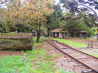
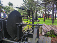
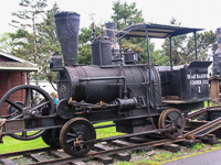
The old Fort Humboldt became a state historic park in 1955, and many of the original buildings that had long since disappeared were reconstructed. What’s been added is equally interesting. With this part of the north coast better known for its logging industry than for its Indian wars, a large collection of historic logging equipment is displayed in sheds and in the open. The equipment includes locomotives and steam donkeys, including a Washington slack-line steam donkey. Loggers used this marvel of late nineteenth century technology to haul huge redwood logs on overhead lines to the locomotive loading areas, sometimes as much as a 0.5 mile away. There is a self-guided trail through the outdoor exhibit area.
During Fort Humboldt’s periodic living history days, logging demonstrations are popular, especially when the steam donkey is fired up.
Directions: The park is located at the south end of Eureka, just off US 101, off Highland Avenue.
Activities: Picnicking, strolling through exhibits.
Facilities: Exhibits, visitor center.
Dates: Open daily.
Fees: There is a day-use fee.
Closest town: Eureka.
For more information: Fort Humboldt State Historic Park, 3431 Fort Ave., Eureka, CA 95503. Phone (707) 445-6567.
Copyright 2015 by Publishing Syndicate, all rights reserved.
For permission to reprint text or photos contact Ken@PublishingSyndicate.com
w138
Fort Point
This underside view of the Golden Gate Bridge is worth seeing, but more intriguing is the brick that went into constructing Fort Point. The U.S. Army Corps of Engineers began blasting the 90-foot cliff at the point in 1853, but work progressed slowly until the threat of the Civil War quickened construction. Finally, in 1861 the first cannon was mounted as Colonel Albert Johnston prepared defenses for the Pacific. His job done, he resigned his commission and joined the Confederate Army. He was later killed at the Battle of Shiloh.
Although the fort never came under attack, the Pacific command saw it as the key to western defenses. But as smooth-bore cannons were replaced by more powerful and accurate breach-loading rifled guns, it became apparent that masonry fortresses could not stand up to modern artillery attacks. Over the next few years, the old guns were removed and other uses, from barracks to a World War II anti-submarine net guard unit, were found.
With waves crashing into the granite seawall at its base, the old, three-story brick fort is an architectural delight. Visitors can wander throughout the structure, up dark staircases all the way to the top deck that once held some of the 69 artillery pieces that were placed in the fort. The fort never mounted all of its planned 141 guns, but it did acquire several 10-inch Rodman guns in the lower casemates. They could fire a 128-pound solid steel shot 2 miles.
Today, most of the cannons are gone, but several similar guns are displayed on the ground floor inside the fort. There’s a great view of the bay from the top of the fort’s walls, properly called the barbette tier, where the old, rusting gun mounts remain. The fort’s three spiral stairways are intriguing. They don’t have central columns for support. Instead, they rely on the weight of the 1,000 pound, hand-cut granite steps sitting on top of one another to hold the stairway structure in place.
Directions: The fort is located at the south end of the Golden Gate Bridge and there are several different approaches via the web of roads that wind throughout the Presidio of San Francisco. From Crissy Field in the Presidio, take Mason Street west, which essentially parallels US 101 to its south. The road will merge into Lincoln, heading northwest. Following the signs, take Long Street, which is another right turn off Lincoln. Follow it to the end, where there’s a small parking lot at the foot of Fort Point.
Activities: Tours, including audio tours.
Facilities: Small visitor center, bookstore, theater.
Dates: Open daily, except Thanksgiving, Christmas, and New Year’s. For a recorded schedule, phone (415) 773-1188.
Fees: None.
Closest town: San Francisco
For more information: Fort Point National Historic Site, PO Box 29333, San Francisco, CA 94129. Phone (415) 556-1693.
Copyright 2015 by Publishing Syndicate, all rights reserved.
For permission to reprint text or photos contact Ken@PublishingSyndicate.com
w139
Fort Ross
State Historic Park
FORT ROSS STATE HISTORIC PARK
The Spanish discovered that attempting to keep other countries from intruding into lands in the New World that they had claimed for themselves was not an easy task. As early as the mid-eighteenth century, Russian trappers had been following seal and sea otter populations down the West Coast from Alaska. Spain countered by pushing its mission settlements farther north into Alta, or northern California. Unfortunately, Spain never settled much farther north than San Francisco, and in numbers so small so as not to make any difference. Thus, it probably wasn’t much of a surprise when California’s Spanish government discovered that in March, 1812, a large group of Russians and their Alaskan laborers had landed just north of the Russian River and had begun building a very substantial wooden fort.
One of the Russians’ first forays into this part of California’s coast resulted in their returning to Mother Russia with over 1,000 sea otter pelts. They soon returned with intentions of staying and farming the land, in addition to hunting sea otters. After the Russians established their permanent settlement, within a short eight years they had hunted the sea otters to near extinction. Although the Russians desired to trade both pelts and agricultural products with the Spanish settlements to the south, Spain remained nervous about her Russian neighbors as well as the American ships also sailing California’s coastal waters. Once the sea otters were gone, the Russian settlement began to fail. Agriculture was not particularly successful on the cold and foggy north coast.
Anxious to leave, in 1841 the Russians finally found an interested buyer named John Sutter, an immigrant who already had established Sutter’s Fort in what would become Sacramento. Sutter’s only real interest was in obtaining the livestock and supplies the Russians were leaving behind. The fort and surrounding land was largely abandoned until George Call acquired it as part of his 15,000 acre ranch in 1873. He used the somewhat sheltered anchorage below the coastal fort as a loading area for timber harvested from his land. The fort and its 3-acre site were given to the State of California in 1906, and since that time over 3, 270 acres have been added. Significant restoration work has been completed on the fort.
A museum and visitor center acts as the entrance to the fort. Exhibits range from Native Americans to the Russian presence in the area. Through the back door of the visitor center there is a short trail that leads to the fort, passing a vegetable garden along the way. The fort’s stout vertical timbers are impressive, even today, as are the cannon muzzles that point out of the gun ports in the corner towers or blockhouses. The interior of the fort is largely open, with only four buildings, in addition to the two corner towers. They include the chapel, reconstructed after the first chapel burned, the manager’s house, the officials’ quarters, and the Russian employee barracks. There is another short trail that provides access to the small beach at the base of the bluff below the fort.
For hikers who like to wander, most of Fort Ross State Historic Park’s 3,700 acres are located on the east side of Highway 1, which bisects the park. It consists of open meadows and redwood forests. Since there are no established trails, the area is open to wandering, mostly uphill. The mountains on the east side of Highway 1 rise to 1,400 feet above sea level. Since the Russians were the first people in California to do extensive logging of redwoods, the park has California’s oldest second-growth redwood trees.
Directions: The park is located about 11 miles north of the town of Jenner and the mouth of the Russian River, just off Highway 1.
Activities: Hiking, beach exploration, whale watching from shore.
Facilities: Visitor center, small gift shop.
Dates: Open daily, except Thanksgiving, Christmas, and New Year’s Day.
Fees: There is a day-use and museum fee.
Closest town: Jenner, 11 miles north.
For more information: Fort Ross State Historic Park, 19005 Coast Highway, Jenner, CA 95450. Phone (707) 847-3286.
Copyright 2015 by Publishing Syndicate, all rights reserved.
For permission to reprint text or photos contact Ken@PublishingSyndicate.com
w140
Golden Gate Bridge
Summer fog, strong winds, and unpredictable currents kept Europeans from discovering the narrow entrance into this perfect harbor until 1769, when Spanish explorers first reached it overland. The discovery was actually an accident. Sergeant José de Ortega was looking for the “lost” bay of Monterey to the south. The Spanish called the gateway La Boca del Puerto de San Francisco. It was American John C. Frémont who used the name Chrysopylae, or Golden Gate for “the form of the entrance into the bay of San Francisco….” Frémont’s choice was the name that stuck.
Many naysayers insisted that constructing the Golden Gate Bridge was folly and that such a bridge could never be built, yet it was opened on May 27, 1937, just four years after construction began. The engineering marvel possesses a long list of statistical information: the suspended main span stretches 4,200 feet; the length of one cable is 7,650 feet and is just over 36 inches in diameter; there are 27,572 individual wires in each cable, totaling 80,000 miles and 24,500 tons; and the towers rise 746 feet above the bay and descend 110 feet below the water’s surface.
Walking the Golden Gate Bridge is an extremely popular activity for the more adventurous, although most people only go part way across before returning, unwilling to walk the nearly 18,000 feet (3.2 miles) round-trip. Choosing a warm, sunny day helps. When fog or cold winds are present, it’s often best to view the bay from inside a car. Parking areas are available on both sides of the bridge. On the San Francisco side of the bay, parking is not far from Fort Point and can be reached either by coming in from Fort Mason on Lincoln Boulevard or by taking the last turn-off (Lincoln Boulevard) before entering the bridge’s toll gates. Don’t miss the turnoff or you’ll have to drive all the way across the bridge and pay the toll to come back south into the city. Dress in warm, layered clothing. On the Marin (south) side of the bridge, the parking lot is just off US 101.
Directions: The Golden Gate Bridge connects US 101 (and Highway 1) between Marin County to the north and San Francisco to the south.
Activities: There is a pedestrian walkway on the east side of the bridge.
Dates: The walkway is open daily.
Fees: There is no fee to use the walkway. There is a vehicle fee collected from all southbound vehicles at tollbooths located on the San Francisco side of the bridge.
Closest town: San Francisco.
For more information: City of San Francisco, phone (415) 666-7200. San Francisco Convention & Visitors Bureau, 201 Third Street, Suite 900, San Francisco, CA 94103. Phone (415) 391-2000.
Copyright 2015 by Publishing Syndicate, all rights reserved.
For permission to reprint text or photos contact Ken@PublishingSyndicate.com
Publishing Syndicate
PO Box 607 Orangevale CA 95662
Ken@PublishingSyndicate.com
Copyright 2010-2016 by Publishing Syndicate: All rights reserved